Land Cover


Global Land Cover
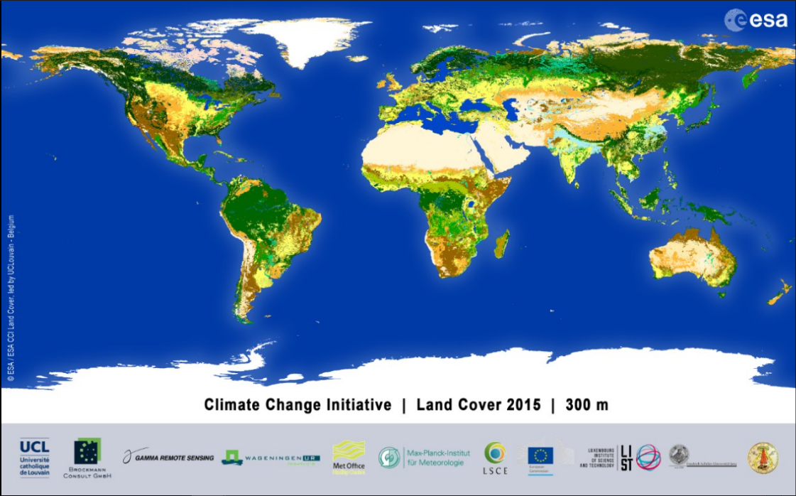
Figure: Global land cover data for the year 2015 (http://www.esa-landcover-cci.org/) Legend and interactive map under: http://maps.elie.ucl.ac.be/CCI/viewer/index.php |
ECV Products and Requirements
These products and requirements reflect the Implementation Plan 2022 (GCOS-244).
The requirements are found in the complete 2022 ECVs Requirements document as well: ECV Land Cover.
| Products | Land Cover | Maps of High-Resolution Land Cover | Maps of Key IPCC Land Classes, Related Changes and Land Management Types | ||||
| (*) | Unit | Values | Values | Unit | Values | ||
| Horizontal Resolution | G | m | 100-300 | <10 | m/degree | 10-300 | |
| B | 300-1 km | 10-30 | 300-1000 | ||||
| T | >1 km | 30-100 | 1000 - 1 degree | ||||
| Vertical Resolution | G | - | - | - | |||
| B | - | - | - | ||||
| T | - | - | - | ||||
| Temporal Resolution | G | month | 1 | 1 | month | 1 | |
| B | 12 | 12 | 12 | ||||
| T | 60 | 60 | 60 | ||||
| Timeliness | G | month | 3 | 3 | month | 1 | |
| B | 12 | 12 | 12 | ||||
| T | 60 | 60 | 60 | ||||
| Temporal Extent (Time span) | G | Y | >50 | 30-50 | Y | >100 | |
| B | 10-50 | 10-30 | 50 | ||||
| T | 0 (one time only) | 0 (one time only) | 30 | ||||
| Required Measurement Uncertainty (2-sigma) | G | % for accuracy and errors of omission and commission and hectares for area estimates incl. 95 % confidence intervals | 5 | 5 | % for accuracy and errors of omission and commission and hectares for area estimates incl. 95 % confidence intervals | 5 | |
| B | 20 | 20 | 15 | ||||
| T | 35 | 35 | 25 | ||||
| Stability | G | % incl. 95 % confidence intervals | 5 | 5 | % incl. 95 % confidence intervals | 5 | |
| B | 15 | 15 | 15 | ||||
| T | 25 | 25 | 25 | ||||
(*) Goal (G): an ideal requirement above which further improvements are not necessary. Breakthrough (B): an intermediate level between threshold and goal which, if achieved, would result in a significant improvement for the targeted application. The breakthrough value may also indicate the level at which specified uses within climate monitoring become possible. It may be appropriate to have different breakthrough values for different uses. Threshold (T): the minimum requirement to be met to ensure that data are useful.
Data sources
This list provides sources for openly accessible data sets with worldwide coverage for which metadata is available. It is curated by the respective GCOS ECV Steward(s). The list does not claim to be complete. Anyone with a suitable dataset who wishes it to be added to this list should contact the abombelli wmo [dot] int (GCOS Secretariat).
- ESA-CCI Land Cover data
- MODIS global land cover data
- Copernicus Global Land Monitoring Service
- GOFC-GOLD
- CEOS Working Group on Calibration and Validation Land Product Validation Subgroup
- Satellite ECV Inventory by the CEOS/CGMS Working Group on Climate (WGClimate)