Surface Wind Speed and Direction


Surface Wind Speed Trends
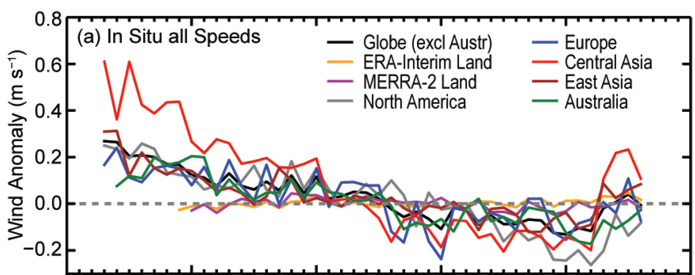
Figure: Estimates of Land surface wind speed anomalies (m s−1) for 1973–2016, relative to 1981–2010: HadISD2 for the globe (excluding Australia) and 4 regions; Australia (1974–2016) is based on an Australian dataset. ERA-interim (1979–2016) and MERRA-2 (1980–2016) anomalies, also shown, cover all land areas. |
ECV Products and Requirements
These products and requirements reflect the Implementation Plan 2022 (GCOS-244).
The requirements are found in the complete 2022 ECVs Requirements document as well: ECV Surface Wind Speed and Direction.
| Products | Wind Direction (near surface) | Wind Speed (near surface) | Wind Vector (near surface) | ||||
| (*) | Unit | Values | Unit | Values | Values | ||
| Horizontal Resolution | G | km | 10 | km | 10 | 10 | |
| B | 100 | 100 | 100 | ||||
| T | 500 | 500 | 500 | ||||
| Vertical Resolution | G | - | - | - | |||
| B | - | - | - | ||||
| T | - | - | - | ||||
| Temporal Resolution | G | h | <1 | h | < 1 | <1 | |
| B | 1 | 1 | 1 | ||||
| T | 3 | 3 | 3 | ||||
| Timeliness | G | h | 6 | h | 6 | 6 | |
| B | 24 | 24 | 24 | ||||
| T | 720 | 720 | 720 | ||||
| Required Measurement Uncertainty (2-sigma) | G | degrees | 1 | m s-1 | 0.1 | 0.1 | |
| B | 5 | 0.5 | 0.5 | ||||
| T | 10 | 1 | 1 | ||||
| Stability | G | degrees/ decade | 1 | m s-1/ decade | 0.1 | 0.1 | |
| B | 2 | 0.25 | 0.25 | ||||
| T | 5 | 0.5 | 0.5 |
(*) Goal (G): an ideal requirement above which further improvements are not necessary. Breakthrough (B): an intermediate level between threshold and goal which, if achieved, would result in a significant improvement for the targeted application. The breakthrough value may also indicate the level at which specified uses within climate monitoring become possible. It may be appropriate to have different breakthrough values for different uses. Threshold (T): the minimum requirement to be met to ensure that data are useful
Data sources
This list provides sources for openly accessible data sets with worldwide coverage for which metadata is available. It is curated by the respective GCOS ECV Steward(s). The list does not claim to be complete. Anyone with a suitable dataset who wishes it to be added to this list should contact the abombelli wmo [dot] int (GCOS Secretariat).
In Situ:
- Integrated Surface Database (ISD) of the National Centers for Environmental Information (NCEI) of the National Oceanic and Atmospheric Administration (NOAA)
- Global Historical Climatology Network Daily (GHCN-Daily) of the National Centers for Environmental Information (NCEI) of the National Oceanic and Atmospheric Administration
- Hadley Centre Integrated Surface Database (HadISD)
- International Comprehensive Ocean-Atmosphere Data Set (ICOADS)
- Wave and Anemometer-based Sea Surface Wind (WASWind)
Reanalysis:
- REANALYSES.ORG (Inventory for Reanalysis)
Satellite:
- Satellite ECV Inventory by the CEOS/CGMS Working Group on Climate (WGClimate)