Leaf Area Index


Leaf Area Index after Fire
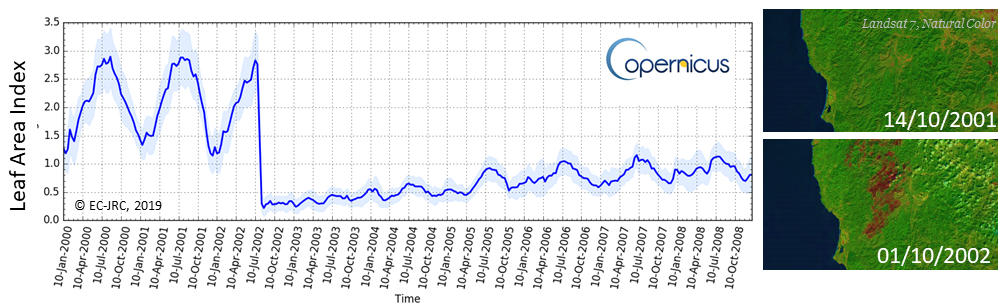
Figure: Time series of LAI (from Copernicus Global Land Service), spatially averaged over 6 x 6 km2, around the Pearsoll Peak, Oregon, United States (42°18’N; 123°51’W). In June 2002, a big fire event occurred. The error bars correspond to the spatial standard deviation around the central pixel. Landsat 7 images from https://earthexplorer.usgs.gov/ |
ECV Products and Requirements
These products and requirements reflect the Implementation Plan 2022 (GCOS-244).
The requirements are found in the complete 2022 ECVs Requirements document as well: ECV Leaf Area Index.
| Products | Leaf Area Index (LAI) | ||
| (*) | Unit | Values | |
| Horizontal Resolution | G | m | 10 |
| B | 100 | ||
| T | 250 | ||
| Vertical Resolution | G | - | |
| B | - | ||
| T | - | ||
| Temporal Resolution | G | d | 1 |
| B | |||
| T | 10 | ||
| Timeliness | G | d | 1 |
| B | 5 | ||
| T | 10 | ||
| Required Measurement Uncertainty (2-sigma) | G | % or m2 m-2 | 10% for values ≥0.5; 0.05 (absolute value) for smaller values |
| B | |||
| T | 20% for values ≥0.5; 0.1 (absolute value) for smaller values | ||
| Stability | G | m2 m-2 / decade | <3% |
| B | |||
| T | <6% | ||
(*) Goal (G): an ideal requirement above which further improvements are not necessary. Breakthrough (B): an intermediate level between threshold and goal which, if achieved, would result in a significant improvement for the targeted application. The breakthrough value may also indicate the level at which specified uses within climate monitoring become possible. It may be appropriate to have different breakthrough values for different uses. Threshold (T): the minimum requirement to be met to ensure that data are useful.
Data sources
This list provides sources for openly accessible data sets with worldwide coverage for which metadata is available. It is curated by the respective GCOS ECV Steward(s). The list does not claim to be complete. Anyone with a suitable dataset who wishes it to be added to this list should contact the abombelli wmo [dot] int (GCOS Secretariat).
- Copernicus Global Land Service providing bio-geophysical products of global land surface
- CEOS Working Group on Calibration and Validation, Land Product Validation Subgroup
- Satellite ECV Inventory by the CEOS/CGMS Working Group on Climate (WGClimate)