Sea Level


Sea Level Rise Map and Global Trend
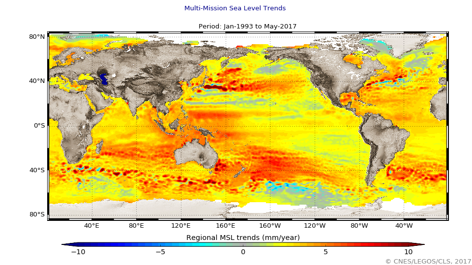
Figure 1: Combined map of regional patterns of observed sea level (in mm/year). This map can be obtained using gridded, multi-mission Ssalto/Duacs data since 1993, which enable the local slopes to be estimated with a very high resolution (1/4 of a degree on a Cartesian projection). Isolated variations in MSL are thus revealed, mainly in the major ocean currents and ENSO events (Credits EU Copernicus Marine Service, CLS, Cnes, Legos). Source: https://www.aviso.altimetry.fr/en/data/products/ocean-indicators-produc… |
ECV Products and Requirements
These products and requirements reflect the Implementation Plan 2022 (GCOS-244).
The requirements are found in the complete 2022 ECVs Requirements document as well: ECV Sea Level.
| Products | Regional Mean Sea Level | Global Mean Sea Level | ||||
| (*) | Unit | Values | Unit | Values | ||
| Horizontal Resolution | G | km | 10 | km | 10 | |
| B | ||||||
| T | 100 | 100 | ||||
| Vertical Resolution | G | - | - | |||
| B | - | - | ||||
| T | - | - | ||||
| Temporal Resolution | G | d | 1 | d | 1 | |
| B | ||||||
| T | 7 | 30 | ||||
| Timeliness | G | month | 1 | d | 30 | |
| B | ||||||
| T | 12 | 365 | ||||
| Required Measurement Uncertainty (2-sigma) | G | mm | mm | |||
| B | ||||||
| T | 10 | 2-4 | ||||
| Stability | G | mm yr-1 | 0.3 | mm yr-1 | <0.03 | |
| B | <0.1 | |||||
| T | <0.1 | <0.3 | ||||
(*) Goal (G): an ideal requirement above which further improvements are not necessary. Breakthrough (B): an intermediate level between threshold and goal which, if achieved, would result in a significant improvement for the targeted application. The breakthrough value may also indicate the level at which specified uses within climate monitoring become possible. It may be appropriate to have different breakthrough values for different uses. Threshold (T): the minimum requirement to be met to ensure that data are useful
Data sources
This list provides sources for openly accessible data sets with worldwide coverage for which metadata is available. It is curated by the respective GCOS ECV Steward(s). The list does not claim to be complete. Anyone with a suitable dataset who wishes it to be added to this list should contact the abombelli wmo [dot] int (GCOS Secretariat).
In Situ
- GLOSS - Global Sea-Level Observing System
Satellite:
- ECV Inventory by the CEOS/CGMS Working Group on Climate (WGclimate)
- Aviso
- JPL PODAAC